
Introduction
Another boring lockdown weekend. Hmmmm! what do I do? I thought.
Since I was currently on an exploration spree of all attractions near Bengaluru, I thought why not check out something on the Bangalore-Kolar highway. After all, I'd been that side so many times for all my Nagala & Antargange treks. And not to mention, all those memorable long drives to Highway Star Kolar with friends. During some of my Antargange visits, I noticed quite a lot of hillocks dotting the landscape, while resting on the peak. I definitely knew that there must be a few with man-made trails around. I got onto Google maps to get a bird's eye view of the area.
I found that not very far from Highway Star Kolar, was another hillock called Avani betta. The pictures online were too captivating for this trek to be passed up on. And so I stopped my search right there and settled for Avani betta. Also, I didn't want to overwhelm myself with more options and have difficulty deciding where to go later on. So for that Sunday, Avani Betta it was!
Let's begin the trek
The best part was, to do this trek, I'd have to cross my favourite
haunt, Highway Star Kolar. Since I started very late that day, I was kind of in between breakfast and lunch while passing by. So I decided not to visit it on the onward journey. Instead, I'd pop in there for lunch on my way back.
I had a pretty late start at 11AM, since I'd woken up late that day:
 |
| Starting at 11 |
I got onto blissful highway roads after battling city traffic:
 |
| gloomy weather |

 |
| Mostly empty roads |
And stopped for a cup of Joe at my favourite cycling haunt, Kolar CCD:


The cloudy, balmy day didn't help with the late start or with the photos. I could have gotten much better photos and good light for photography on a cloudless, sunny day. Heat from the sun is a non-issue for me since I'm used to summer treks. And even if it does get sunny on these Bangalore treks, the heat doesn't get to you the way it does in Andhra Pradesh, and I'm not sure if this is because of the surrounding greenery, or just the general Bangalore effect.
The route was fairly easily and comprehensible. All you have to do is stick to the main Kolar highway, and then take a right turn to get off the main highway at the point where Google maps tells you to, and drive for around 8kms. However, be cautioned that Google might not really take you to the correct starting point, which was exactly what happened to me.
After going through the winding curvy village roads for a few kilometers, you'll arrive at a junction. From there I could clearly see the temple arch and a road leading to the hill. But Google maps told me to keep going straight for another 3 km's, and that I'd arrive at the starting point for the trek. I zoomed into the map to see what google was up to, and thought "alright, its making me do the trek in the opposite direction, maybe the trail goes both ways". But when I got to Google's start point, I stared at a blank field with just a house or two next to it. When I parked and got off, the villagers told me this isn't the start point for the trek, and neither is there any trek-able route from here. I thought Google might only be showing me the road, and that the trail might naturally present itself when I got there. But that was not the case. The people were right.
The area I arrived at by following Google maps:


Based on the directions they were giving me in Kannada, I understood that I was correct some time back, and the arch point was indeed the correct entry to the temple/trek point. So I backed up to the main road and then started for the junction. I crossed the mud road again and then arrived at the intersection. I took the left turn, inquired with a few people standing there, and they immediately confirmed that I was on the right path. So I went on, and I could clearly discern a temple in the distance at what seemed to be a dead end.
When I got to the temple, it was in fact, not a dead end, and there was a road going towards the right. A throng of villagers and tourists were standing right outside the temple, and I thought they were there to chase people away due to the Covid 19 situation, but considering no one in the village wore masks, I knew it must not be the case. When I spoke to them, they turned out to be super kind, and told me to take the road on the right, and that I'd arrive at the trail in just a few metres.
 |
| Temple car |
 |
| The entry as seen from a distance |
 |
| second junction |
 |
| Temple you first arrive at |
 |
| Road that went right |
I took the right turn, arrived at another triangular looking junction, and I could make out the hill on the left side, and instinctively took it without asking anyone nearby. Once you take this road, you know you've arrived, as the arch is clearly visible from a distance. There were a couple of cars parked right in front of it. So I had to go and park towards the left.
On parking the car, I noticed that the distance was 100kms by the time I had gotten there:

After parking, I immediately began the trek:


 |
| Cinematic views all around |


 |
The trek starts off with stairs, and this makes it an extremely easy trek for beginners. I'd recommend this place as a first hike for someone who'd like to get into trekking. It's even great for someone who's taken a long break from treks and would like to restart. I was surrounded by boulders on all sides of the hill. There were small ones, big ones, and some that slanted at such awkward angles, it looked like they might just roll down any second. There was just another group of trekkers ahead of me and they seemed to be doing pretty fine. Due to the cloudy sky, there was no heat at all, but neither was it cool. It was just pleasant and salubrious.
The Stairs weren't continuous. At some places they were barely carved into the stone, that the slabs looked more stone, and less stair. After a 100 metres or so of climb, there was an opening where a separate set of stairs veered off towards the right, away from the main path leading to the peak. I decided to go and check it out. It led to a place where two huge boulders slanted against each other, creating a sort of cave, with enough space to shelter from the elements.


 |
| The path that led towards the right side |
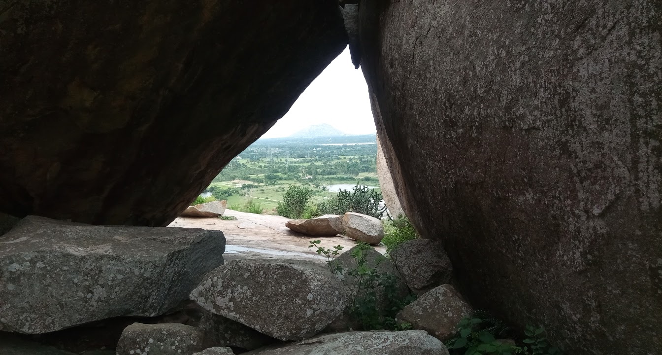 |
| The cave structure |

I spent some time inside this cave gingerly clicking photos and resting for a bit. I hadn't trekked for months, owing to the lock down. It wasn't hot, or even sunny for that matter, so I didn't find the need to carry a water bottle. Bad decision. I realized that it was not the trek, but the caffeine that dehydrated me more than anything else.
On getting out of the cave on the other side, I found a few cactus plants along with a ton of free-standing boulders, and started taking pics of them. I also noticed that I wouldn't necessarily have to rejoin the main trail, and that I could just continue the trek from where I was, since it joined the trail eventually.
Cacti and Boulder formations:


 |
| Quarry can be seen in the background |


 |
| Temple can be seen in the distance |

 |
| The arch leading back to the trail |
 |
| Majestic boulders all along the route |
On emerging out of the cave the other side, I noticed a wall running along the perimeter of the hill for some distance, which then abruptly ended. When I went all the way to that side, I found a pond, next to which a family had laid out their picnic mat and were having lunch. The kids seemed to be quite excited about the place, but so were the elders. A bit ahead of this pond was a second pond, where I went to have some lone time.
I noticed a route joining the trail where there was an arch made out of stone. I decided not to take it immediately and instead chose to explore further a bit ahead. It led to an open land that overlooked the majestic view of the entire landscape. You could see a quarry, a lake, and the approach road from this view point. It was a truly magical scene, with shades of brown and green painted all over, in the backdrop of a cloudy, but blue sky.
 |
| Second pond |

 |
| First pond |
 |
| First pond |
 |
| A structure right next to the first pond |

 |
| Do you know why these stones are tied? |
I noticed a peculiar looking cactus plant, where a bunch of stones tied into a cloth bag were hung on them. At that point I didn't know the reason for this. But when I got back home, my folk told me that people come to the temple on the top of this hill to pray for a child. These stones were tied as vows, so that the couple may be blessed with a child in future. I realized that the number of stones tied to this cactus was actually nothing when I reached the temple area, where entire trees were covered in such stone bags.
Also, you'll find a lot of the famous "stacked rocks" on this hill, the universal trekker sign for "I've been here", or "this is the way".
The globally recognized "I've been here" sign:
 |
 |
| Yes, there was a bit of garbage |


There was a bit of garbage near these rocks but not anywhere else on the hill. It's definitely one of the cleanest hills I've been to close to the city. After lounging around the area for a while and taking in the beautiful views, I decided to move towards the temple.
I found another pond on the way up that was too beautiful to pass up:


On crossing that pond and climbing further up, I came across this huge potato looking boulder with a small pond that had formed next to it:


There was a railing to protect people from falling into the water, as the surface of the stone near the pond was very smooth and slanted towards it.
I tried to get a pic of the fishes in the pond. Luckily, I was successful at it:

Without further wasting time, or resting, I trekked further and was dazzled by even more beautiful boulder formations on the way:
 |
| Absolutely spectacular |
I finally arrived at the temple after a bit more climbing. The stairs began here again, and they continued all the way till the temple. The stairs were so neatly laid, and the way the plants grew around them, it almost felt like someone was hired to landscape the place and clean it everyday. Who knows? That actually might be the case!


Right before arriving at the temple you'll see the vow trees I mentioned a while back:


At the peak, you get a panoramic views of Avani town, which looks spectacular amidst all the natural brown and green shades of the countryside:


I quickly realized that it was getting late and I had to move from there. As it is, I couldn't explore much of the hillock due to my late start, and regretted it. I had to abandon the exploration midway, and make my way back to the car as the sky was overcast and it could rain any time. I had neither carried any rain protection, nor had I dressed for a rainy trek. So with that, I began my descent. There were a few families who were making their way up as I was descending, and it was then that I realized I wasn't that late after all. It was only because of the cloudy weather and overcast sky, that I was fooled into believing that it was evening. So I slowed down to catch my breath, and heaved a sigh of relief. By the time I got back to the car, it was already 4 PM. A terribly bad time for lunch. But I had had breakfast at 11, so what was the hurry?
I got myself a burger from McDonalds at Highway Star, and took it 'to go', so that I could eat while driving. It was around 5 by the time I left from there. The drive back home was very blissful, owing to less traffic on the highway itself, and very less movement in the city interior. I comfortably got home at around 6. It was 200kms on the trip meter. All in a day's work, and a weekend done right!